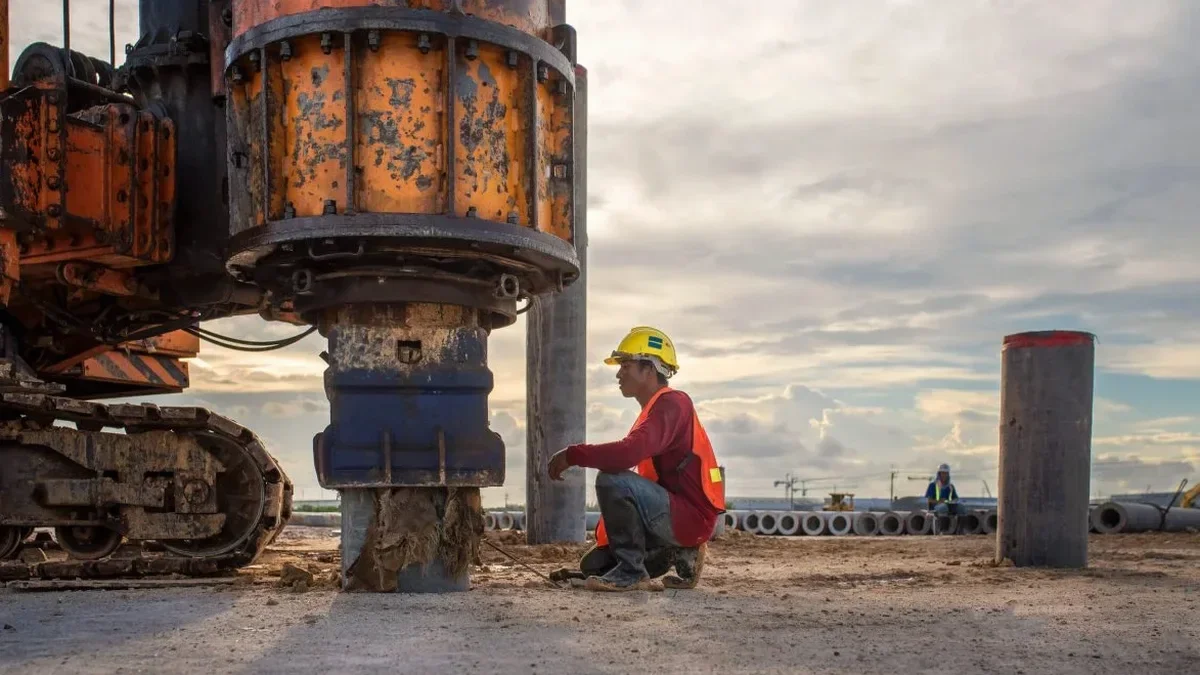
The 24-channel land streamer rolls across a graded pad near Lake Pleasant Parkway, its 4.5 Hz geophones pressed tight against the desert pavement by a tow vehicle creeping at walking speed. In Peoria, Arizona — where the surface geology shifts from young alluvial fans to cemented caliche within a few hundred feet — this active-source MASW array captures Rayleigh wave dispersion down to 100 feet of depth, extracting a VS30 profile that feeds directly into IBC Chapter 16 site classification. The sledgehammer source on an aluminum plate produces a clean frequency sweep, and the seismograph stacks five blows per shot point to suppress background noise from nearby construction traffic along the Loop 303 corridor. Crews working the northwest Valley know that Peoria's basin-edge position means shear wave velocity often jumps from Site Class D to C across a single parcel, and they set up multiple lines to catch that boundary before the structural engineer locks in the foundation design. Complementing the surface wave method, we often pair it with seismic refraction when the client needs a P-wave velocity cross-section for rippability estimates alongside the VS30 determination.
Peoria's basin-edge geology means VS30 can change from 1,200 ft/s to 2,500 ft/s inside a single lot — we run multiple spreads to catch that boundary.
Methodology applied in Peoria Arizona
Typical technical challenges in Peoria Arizona
Peoria's development arc tells a geotechnical story in fast-forward: what was citrus groves and desert scrub along Grand Avenue in the 1970s became master-planned subdivisions pushing into the foothills by the 2000s, and now the Vistancia and North Peoria corridors are grading pads on Pleistocene terrace gravels that sit directly over fractured granitic bedrock. The seismic risk that keeps structural reviewers awake is the sharp impedance contrast at the soil-rock interface — a condition that amplifies short-period ground motion and can shift a site from Site Class C to D if the upper 30 meters contain enough stiff soil to pull the VS30 average below 1,200 ft/s. Missing that boundary by 50 ft of lateral offset can overestimate the design base shear by 15 to 20 percent, or worse, underestimate it. The IBC explicitly requires a site-specific shear wave velocity measurement rather than relying on blow-count correlations for sites with potential Site Class C/D transitions, and Peoria's basin-edge location — where the depth to the crystalline basement changes rapidly from north to south — makes the MASW survey a non-negotiable item in the geotechnical scope for any structure taller than two stories.
Our services
The MASW survey delivers a VS30 number for the building permit package, but Peoria projects frequently need additional geophysical and geotechnical data to satisfy the City of Peoria Engineering Design Standards and the structural peer review. Our team runs these complementary services from the same field mobilization:
MASW / VS30 Site Classification
Active-source 2D MASW profiling with 24-channel land streamer, delivering 1D VS profiles and IBC-compliant VS30 values for Site Class A through F determination.
Seismic Refraction Tomography
P-wave refraction surveys on the same spread for rippability assessment, depth-to-bedrock mapping, and groundwater table identification in Peoria's alluvial basin.
Downhole Seismic Testing
Downhole PS suspension logging in a cased borehole for sites requiring direct-interval VS measurement, often paired with SPT sampling for lithologic control.
Liquefaction Potential Analysis
Seed & Idriss simplified procedure using SPT blow counts and fines content, applied to saturated granular layers in the Agua Fria River floodplain for seismic settlement estimates.
Frequently asked questions
What does a MASW survey in Peoria cost, and what drives the price range?
A typical active-source MASW survey for a single-family or light commercial lot in Peoria runs between US$1,710 and US$3,540. The spread depends on the number of spreads required — a single 115-foot line for a residential pad sits at the lower end, while a three-line orthogonal survey for a commercial building with Site Class C/D boundary verification moves toward the upper end. Mobilization distance from our staging yard, permit expediting through the City of Peoria, and data processing turnaround time also factor into the final figure.
How deep does the MASW method investigate in Peoria's desert soils?
With a 115-foot active-source spread and a sledgehammer energy source, we consistently resolve shear wave velocity profiles to 80-100 feet below grade in Peoria's typical alluvial fan deposits. The maximum depth depends on the stiffness of the near-surface materials: in the cemented caliche horizons common in the northern Peoria foothills, the high-frequency Rayleigh waves attenuate faster and the useful depth may limit to 60-70 feet. For deeper investigation — say, 150 feet or more — we switch to a passive-source microtremor array or a downhole PS suspension log.
Why can't you just use SPT blow counts to estimate VS30 for my Peoria site?
The IBC 2021 and ASCE 7-22 explicitly permit blow-count correlations for Site Class determination only when the site is clearly Class C or better and the soil profile is well-characterized by borings. Peoria's basin-edge geology, where the depth to rock varies sharply and the alluvial column contains interbedded gravel, clay, and caliche, falls squarely into the category where site-specific shear wave velocity measurement is required — particularly if the design professional is targeting a Site Class C classification for seismic base shear reduction. Blow-count correlations carry a coefficient of variation exceeding 30% in these heterogeneous deposits, and a MASW survey reduces that uncertainty to under 10%.
How long does the field work take, and what access do you need?
A two-person crew can complete three 115-foot MASW spreads on a graded pad in approximately four hours, including the initial seismograph calibration and geophone coupling checks. We need a relatively flat, cleared working surface — the land streamer tolerates minor vegetation but not deep ruts or loose cobble. The source impacts generate a sharp acoustic report, so we coordinate with the general contractor if adjacent occupied structures are within 200 feet. The final report with VS profiles, dispersion curves, and the VS30 Site Class letter is typically delivered within five business days of field completion.