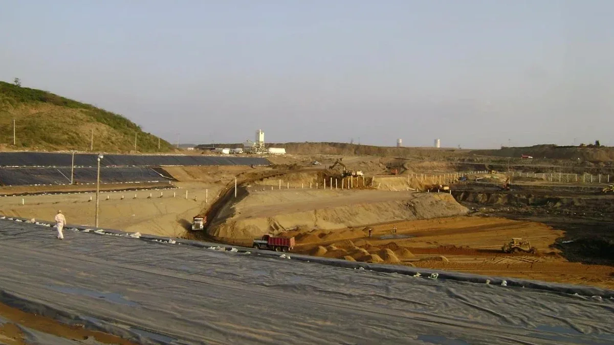
With Peoria sitting at roughly 1,140 feet in elevation along the northwest edge of the Phoenix metropolitan area, the subsurface conditions here are anything but predictable. The city’s rapid expansion north toward Lake Pleasant has pushed new commercial and residential projects into the old river terraces of the Agua Fria, where we encounter complex cemented alluvium and caliche lenses that behave like rock one minute and crumble the next. These materials demand a geotechnical design for deep excavations that goes beyond typical textbook solutions. The team here has been involved in multiple parking garage and pipeline trench projects where the depth of the weathered zone varied by over ten feet within a single block. Getting the design right means understanding how these desert hardpans form, and that comes from logging hundreds of borings across the city. Combining local drilling data with spt-drilling profiles allows us to map the refusal layer with confidence before shoring ever begins.
In Peoria’s desert hardpans, what looks like rock on the surface can behave like soil under load — staged excavation modeling is non-negotiable.
Methodology applied in Peoria Arizona
Demonstration video
Typical technical challenges in Peoria Arizona
A Caterpillar 349 excavator can pull out a surprising amount of material in a morning shift along Peoria’s northern corridors, but the real danger isn’t the production rate — it’s what happens when the bucket teeth hit an unexpected lens of uncemented sand beneath a rigid caliche roof. We have seen vertical faces of 15 feet stand unsupported for days during the dry season, only to ravel apart within hours after a monsoon storm saturates the silty seams. The combination of high summer temperatures, flash flood potential, and the brittle nature of desert hardpan creates a unique risk profile for deep excavation design. A sudden loss of suction in the partially saturated zone can reduce apparent cohesion to near zero, triggering a progressive failure that starts deep in the trench before any warning crack appears at the surface. That is why our designs for Peoria always include a solid surface water management plan and specify real-time excavation-monitoring with inclinometers and piezometers when the cut exceeds 20 feet.
Our services
Deep excavation design in Peoria integrates several investigation and stabilization disciplines. The services we coordinate for these projects include:
Shoring System Design
Complete design of soldier pile, secant pile, and soil nail walls tailored to Peoria’s cemented alluvium and caliche, with staged excavation sequencing and lateral deflection analysis.
Dewatering and Drainage Plans
Design of temporary dewatering systems for perched water zones and post-monsoon infiltration, including sump placement and surface diversion to protect open cuts.
Construction-Phase Monitoring
Installation and interpretation of inclinometers, optical survey targets, and standpipe piezometers to verify design assumptions during excavation near active roadways and utilities in Peoria.
Frequently asked questions
How deep can an excavation go in Peoria before needing tie-backs or internal bracing?
In the cemented alluvium typical of Peoria, cantilever soldier pile walls can often reach 12 to 15 feet without tie-backs, provided there is no surcharge from adjacent structures. However, once the cut exceeds 18 feet or approaches property lines, we typically introduce at least one row of post-tensioned anchors or internal struts. The final decision depends on the continuity of the caliche layer, which we verify through test pits and SPT borings along the wall alignment.
What kind of maintenance is required for a temporary shoring wall during Peoria’s monsoon season?
The biggest threat during the monsoon is surface water entering the excavation and eroding the soil at the base of the wall. We recommend inspecting the shoring system after any storm delivering more than 0.5 inches of rain. Check for raveling behind the lagging, erosion at the toe, and any movement in the tie-back anchor plates. Temporary berms or swales around the perimeter should be cleared of debris to keep runoff flowing away from the cut.
Do the caliche layers in Peoria eliminate the need for a geotechnical investigation for deep excavations?
Absolutely not. While caliche can be very strong in compression and can stand vertically for short periods, its thickness and continuity are notoriously erratic in the Peoria area. We have encountered sites where caliche pinches out over a distance of 30 feet, leaving uncemented granular soils directly behind a shoring wall. A proper investigation with borings and laboratory strength testing is essential to avoid assuming rock-like behavior in a soil that can deteriorate when exposed to air and moisture.
What is the typical cost range for geotechnical design of a deep excavation in Peoria?
For a comprehensive design package — including subsurface investigation planning, shoring wall design, dewatering recommendations, and construction-phase monitoring specifications — the fee typically ranges from US$2,240 to US$7,510, depending on the excavation depth, proximity to adjacent structures, and the complexity of the soil profile encountered.